Monitoring & Evidence
Our objectives can be achieved through various means such as but not...
View page

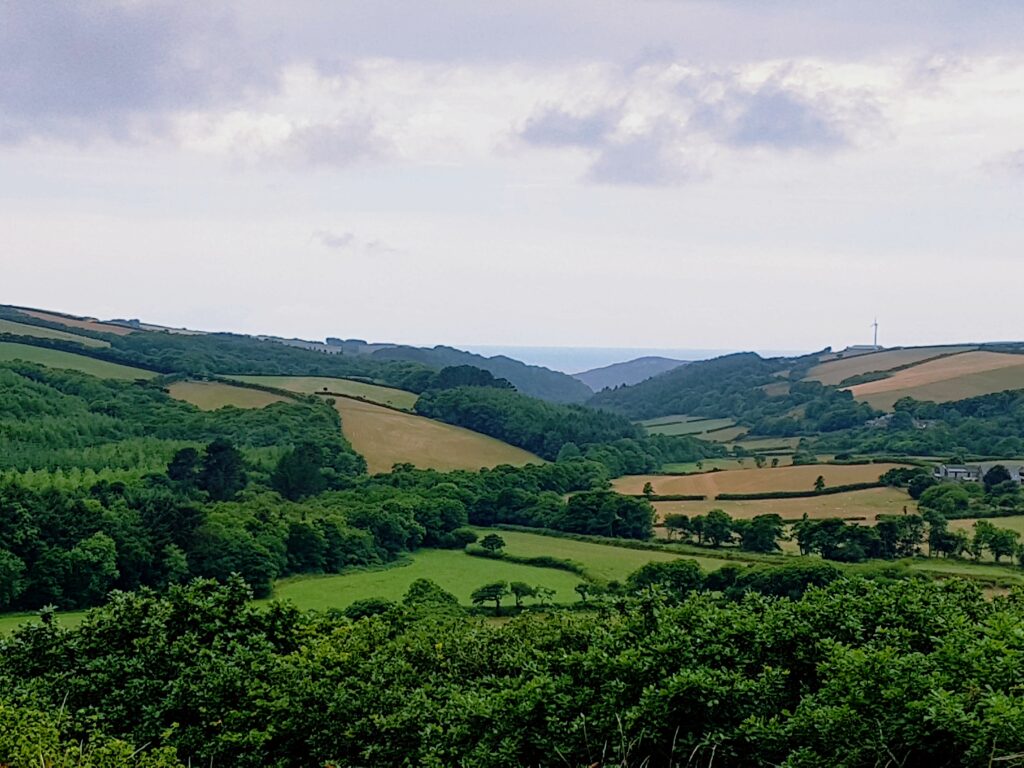
The key landscape characteristic of this section is a high coastal plateau of carboniferous sandstones and slates known as the Culm Measures. The cliffs are sheer; reaching 140m in some places and are intensely folded and faulted. The sea has sculpted a striking wave-cut platform, which at low tide reveals a rock stratum of folded and faulted ridges. These shores are punctuated occasionally by sandy coves and beaches at the mouths of stream valleys, notably at the aptly named Sandymouth.


This small section of the AONB runs southwards from the Devon border to just above Bude. It shares a boundary with the North Devon AONB at its eastern boundary and more or less follows the A39 trunk road (Atlantic Highway) to Menapoint Church.
| AONB Section | Cornwall's Landscape Character areas | Marine Character Areas covering the coast/adjacent waters |
|---|---|---|
|
CA37: Western Culm Plateau CA38: Bude Basin |
MCA 44: Hartland Point to Port Isaac Bay |
The Key Landscape Characteristic of this section of the AONB is a high coastal plateau of carboniferous sandstones and slates known as the Culm Measures. The cliffs are sheer; reaching 140m in some places and are intensely folded and faulted. The sea has sculpted a striking wave-cut platform, which at low tide reveals a rock stratum of folded and faulted ridges. These shores are punctuated occasionally by sandy coves and beaches at the mouths of stream valleys, notably at the aptly named Sandymouth.


The National Trust manages land specifically around the coastline at Morwenstow and from Duckpool to Sandymouth.

Much of the coastline in the Hartland section of the Cornwall AONB is included in the ‘Steeple Point to Marsland’ SSSI (Site of Special Scientific Interest) and SAC (Special Area of Conservation). The sea off Hartland Point to Tintagel is designated as a Marine Conservation Zone.

Key species of interest for this section are Peregrine, Atlantic woodlands, Chough, Rare lichens,
The Monumental Improvement project will ensure that 38 Scheduled Monuments in the Cornwall National Landscape will be better identified, supported and enjoyed by a wide range of communities and visitors.
Perched high on a hill, Kilkhampton Castle (also known as Penstowe Castle) has watched over the land since its construction during the turbulent 1100’s.


This Farming in Protected Landscapes (FiPL) grant recipient was awarded funding to develop and deliver activity plans to engage the local community in the management and care of the dunes.

Farming in Protected Landscapes (FiPL) is a programme providing grant-funding for Farmers and Landowners designed to deliver for People, Place, Nature and Climate. The programme is funded by Defra and delivered by Cornwall National Landscape.
FiPL is helping to address the climate and biodiversity crisis, improve people’s engagement with the landscape, and support sustainable farm businesses and communities.

Our aim is to strengthen the living connections between people, place, nature and climate so that Cornwall’s landscapes can thrive for generations to come.
To connect people, place, nature, and climate through digital innovation, amplifying voices and protecting Cornwall’s natural and cultural heritage.
A collaborative project uniting Cornwall’s landscapes, people, and nature, using innovation and local voices to protect natural and cultural heritage and shape a thriving future.
Open this panel to load the interactive map.
Open this panel to load the interactive map.
Open this panel to load the interactive map.
Open this panel to load the interactive map.
The policies and objectives below are applicable to this Local Section – they should, however, be read in conjunction with the Cornwall AONB Strategy Aims, Policies and Objectives which are applicable to the whole designation.
Require all development to support the conservation and enhancement of the undeveloped character of the coast, in order to retain its rugged and simple tranquillity, maintaining the sparsely populated settlement pattern and tranquil characteristics of this section of the Cornwall AONB. Respect local vernacular, scale and use of materials that makes this area distinctive.
References to the main aims, policies & objectives
 Policy LS-P1
Policy LS-P2
Policy LS-P3
Policy LS-P4
Policy LS-P6
Objective LS-Ob1
Objective LS-Ob2
Objective LS-Ob3
Objective LS-Ob4
Objective LS-Ob6
Policy LS-P1
Policy LS-P2
Policy LS-P3
Policy LS-P4
Policy LS-P6
Objective LS-Ob1
Objective LS-Ob2
Objective LS-Ob3
Objective LS-Ob4
Objective LS-Ob6
 Objective NRLM-Ob9
Objective NRLM-Ob10
Objective NRLM-Ob11
Objective NRLM-Ob9
Objective NRLM-Ob10
Objective NRLM-Ob11
 Policy CCBR-P1
Objective CCBR-Ob4
Policy CCBR-P1
Objective CCBR-Ob4
 Objective HC-Ob1
Objective HC-Ob7
Objective HC-Ob11
Policy RSA-P1
Policy RSA-P3
Policy RSA-P4
Objective HWB-Ob2
Objective HWB-Ob5
Policy SCE-P2
Policy SCE-P3
Policy SCE-P5
Policy SCE-P6
Objective SCE-Ob1
Policy PD-P1
Policy PD-P2
Policy PD-P3
Policy PD-P7
Policy PD-P12
Policy PD-P14
Policy PD-P18
Objective HC-Ob1
Objective HC-Ob7
Objective HC-Ob11
Policy RSA-P1
Policy RSA-P3
Policy RSA-P4
Objective HWB-Ob2
Objective HWB-Ob5
Policy SCE-P2
Policy SCE-P3
Policy SCE-P5
Policy SCE-P6
Objective SCE-Ob1
Policy PD-P1
Policy PD-P2
Policy PD-P3
Policy PD-P7
Policy PD-P12
Policy PD-P14
Policy PD-P18
Seek to maintain current low levels of light pollution in order to maintain dark night skies.
References to the main aims, policies & objectives
Seek a reduction in landscape and visual impacts of tourism including better integration of holiday sites, visitor infrastructure and signage by respecting local character in external works, landscaping, site design and layout. Pay particular attention to the increase in scale, massing and associated development for example, but not limited to, Duckpool, Sandymouth and Morwenstow.
References to the main aims, policies & objectives
Support opportunities to increase the awareness and protection of the heritage of the area, in order to promote, conserve and enhance landscape character and natural beauty, paying particular attention to those that may be impacted upon by coastal change.
References to the main aims, policies & objectives
Policy LS-P1
Policy LS-P2
Policy LS-P4
Policy LS-P6
Objective LS-Ob1
Objective LS-Ob2
Objective LS-Ob3
Objective LS-Ob4
Objective LS-Ob5
Objective LS-Ob6
Objective NRLM-Ob10
Objective CCBR-Ob4
Objective HC-Ob1
Objective HC-Ob3
Objective HC-Ob4
Objective HC-Ob6
Objective HC-Ob7
Objective HC-Ob8
Objective HC-Ob9
Objective HC-Ob10
Objective HC-Ob11
Objective HC-Ob12
Objective HC-Ob13
Objective HC-Ob14
Policy RSA-P3
Objective RSA-Ob3
Objective RSA-Ob5
Objective HWB-Ob1
Objective HWB-Ob2
Objective HWB-Ob3
Objective HWB-Ob4
Policy SCE-P2
Policy SCE-P5
Policy SCE-P6
Objective SCE-Ob1
Objective SCE-Ob2
Objective SCE-Ob4
Consider the small-scale planting of local provenance native tree species such as Sessile Oak, Hazel and Alder to act as a future seed source for native woodland establishment where this is currently absent or sparse to assist subsequent natural regeneration.
References to the main aims, policies & objectives
Policy LS-P1
Objective LS-Ob1
Objective LS-Ob2
Objective LS-Ob3
Objective LS-Ob4
Objective LS-Ob5
Objective NRLM-Ob1
Objective NRLM-Ob2
Objective NRLM-Ob3
Objective NRLM-Ob5
Objective NRLM-Ob12
Objective NRLM-Ob13
Policy CCBR-P1
Objective CCBR-Ob1
Objective CCBR-Ob2
Objective CCBR-Ob3
Objective SCE-Ob1
Objective SCE-Ob2
Objective SCE-Ob4
Encourage sensitive management and potential removal of Sycamores in native broadleaved woodlands in a manner that is consistent with conserving and enhancing local landscape character, and biodiversity, and provided regeneration can occur using native species. Particularly at Coombe Valley, Stanbury, The Tidna, and Marsland Valley.
References to the main aims, policies & objectives
Related topics and useful links
The Management Plan is a shared strategy for those who live, work and visit the Cornwall Area of Outstanding Natural Beauty.
Further details on the Monument Improvement Project


