Monitoring & Evidence
Our objectives can be achieved through various means such as but not...
View page

The key landscape characteristics of this section of Cornwall National Landscape is a distinctive upland landscape which is created from the underlying granite mass, the largest of several granite intrusions that penetrate the slate killas bedrock along the spine of Cornwall. The highest point of the moor is in the northwest at Brown Willy a peak of 420m. Across the valley, the slightly lower Roughtor hosts the remains of a 12th century medieval chapel, and together, they represent the highest points of land in Cornwall.


This is the largest section of land in the AONB and includes both open and enclosed moorland, bisected northeast to southwest by the main A30 trunk road. It extends to Davidstow Moor in the north, Upton Cross in the east, St Neot in the south and Tresarrett in the west.
| AONB Section | Cornwall's Landscape Character areas |
|---|---|
|
CA21: Fowey Valley CA22: South East Cornwall Plateau CA26: East Cornwall and Tamar Moorland Fringe CA29: Middle Tamar Valley CA32: Bodmin Moor CA33: Camel and Allen Valleys |
The Key Landscape Characteristics of this section of the AONB is a distinctive upland landscape which is created from the underlying granite mass, the largest of several granite intrusions that penetrate the slate killas bedrock along the spine of Cornwall. The highest point of the moor is in the northwest at Brown Willy a peak of 420m. Across the valley, the slightly lower Roughtor hosts the remains of a 12th century medieval chapel, and together, they represent the highest points of land in Cornwall.
Extensive, unenclosed high moorland is grazed by hardy weather-beaten cattle, sheep and ponies according to historic laws governing common land. This grazing plays an essential role in controlling scrub thereby maintaining the distinctive openness of this landscape. In parts the moor has never been enclosed. In other areas, past efforts at enclosure are long abandoned leaving enigmatic vestiges of past attempts to tame the land.
Edging the open moorland, larger fields show enduring recent enclosure whilst nestling in sheltered folds at lower levels anciently enclosed farmland is recognisable by its smaller fields with irregular boundaries. This long historic process of attempts to tame the open moor has created a fascinating texture of intermingling pockets of commons and enclosures that distinguishes Bodmin Moor from most other upland landscapes.

Gorse and bracken add to the roughness of the unimproved acid grassland of some commons whilst at the heads of streams on higher ground between hills poor drainage and substantial rainfall create a rich and
interesting patchwork of fens, wetlands, quaking bogs and other valuable habitats emphasising the sense of remote exposure.
Golitha Falls is a geological feature, where the river Fowey tumbles down a series of low waterfalls bounded by large mounds of lichen covered granite and runs through an ancient wooded valley of sessile oak and ash – a complete contrast to the barren moor upstream. The area surrounding Golitha Falls is rich in flora and fauna and is one of the three National Nature Reserves in Cornwall.


State of the AONB Report 2021
The Monumental Improvement project will ensure that 38 Scheduled Monuments in the Cornwall National Landscape will be better identified, supported and enjoyed by a wide range of communities and visitors.
Tresibbet is the remains of a small medieval farming hamlet(s) on Bodmin Moor, where people lived and worked nearly 800 years ago.

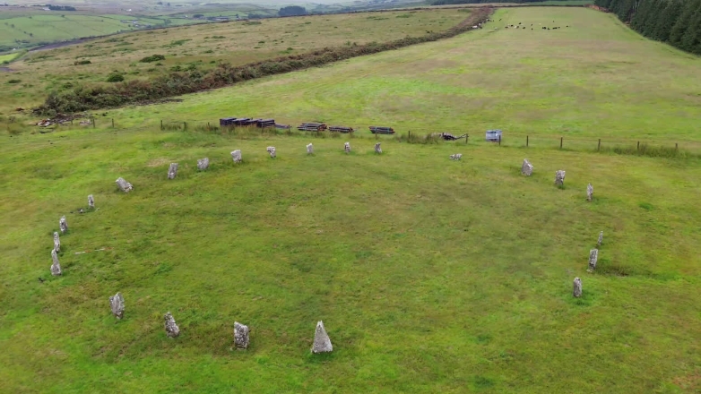
The Goodaver Stone Circle is a ring of tall granite stones on Bodmin Moor, where about 23 big standing slabs make a circle nearly 32 metres wide.
Tucked away on the edge of Bodmin Moor, these three stone hut circles have been quietly sitting here for thousands of years.

The Bearah Tor Boundaries are prehistoric stone banks and a cairn on Bodmin Moor that once marked out ancient land divisions and burial places, now hidden in parts by bracken and gorse

A Neolithic long cairn and associated prehistoric field systems located on Bearah Common, eastern Bodmin Moor.

Hidden on the quiet Bearah Common, this small, grassy bump holds a secret from the Bronze Age, a simple stone grave where someone was carefully buried over 4,000 years ago.

The rectangular arrangement of stones near Wardbrook Farm is the remains of a cist, a type of funerary monument built during the Bronze Age, between 2600 and 800 BC.

Tucked away on the wild slopes of Bodmin Moor, this tiny stone hut tells the story of how early medieval herders lived during summer months in the hills.

High on the wild moorland of Bodmin, Stowe’s Hill Fort has stood for thousands of years. This rocky hill hides ancient secrets – stone walls, burial places and even homes where people once lived, gathered and looked after animals. It’s a place where the past peeks through the stones, telling stories from long ago.

High up on Bodmin Moor, Nine Stones Circle is a peaceful and mysterious Bronze Age site where people gathered over 4,000 years ago maybe to mark the seasons, hold ceremonies, or honour their beliefs.

Hidden away on Bodmin Moor, King Arthur’s Hall is a mysterious Neolithic monument built over 5,000 years ago.

Emblance Downs Stone Circles are an important prehistoric site on Bodmin Moor, featuring two distinct stone circles. The western circle is better preserved, with six upright stones and at least one fallen, while the eastern circle is more difficult to see, with only two stumps and four fallen stones remaining. These circles, dating back to the Bronze Age, are thought to have been used for ceremonial purposes by early inhabitants, adding mystery to the landscape.

Fox Tor Stone Alignment is a prehistoric monument on the wild moorlands of Cornwall dating back to the late Neolithic or early Bronze Age.


Treveddoe Farm, located in Warleggan within Section 12 (Bodmin moor) of Cornwall National Landscape, underwent a remarkable transformation through the Farming in Protected Landscapes (FiPL) programme. Led by farmer Ben…

The BEAST (Bodmin Environment Arts Science Theatre) project was an innovative initiative by Cornwall National Landscape designed to connect communities with nature through art and cultural experiences. Rooted in the…

Farming in Protected Landscapes (FiPL) is a programme providing grant-funding for Farmers and Landowners designed to deliver for People, Place, Nature and Climate. The programme is funded by Defra and delivered by Cornwall National Landscape.
FiPL is helping to address the climate and biodiversity crisis, improve people’s engagement with the landscape, and support sustainable farm businesses and communities.

Our aim is to strengthen the living connections between people, place, nature and climate so that Cornwall’s landscapes can thrive for generations to come.
To connect people, place, nature, and climate through digital innovation, amplifying voices and protecting Cornwall’s natural and cultural heritage.

Some Cornish Hedges are over 3,500 yrs old! Making them one of the oldest human-made structures still used for their original purpose. As old as the Pyramids, neither a hedgerow or a dry-stone wall, they are unique and mainly found in Cornwall.
Despite their importance, there is a significant gap in evidence at scale to fully capture the contributions of Cornish Hedges to ecosystem services and natural capital value.
The policies and objectives below are applicable to this Local Section – they should, however, be read in conjunction with the Cornwall AONB Strategy Aims, Policies and Objectives which are applicable to the whole designation.
Support improved restoration of china clay workings at Lower Hawkstor, Parson’s Pit, and Stannon Pit in keeping with the local landform, soils and vegetation communities of their moorland setting whilst respecting local history and heritage. Support further measures to protect and enhance environmental quality, and increase biodiversity, when existing quarrying permissions are reviewed.
References to the main aims, policies & objectives
Require improved integration into the landscap of existing visitor facilities and car parks such as at Golitha Falls, Minions and Roughtor Road in order to reduce their existing landscape and visual impacts.
References to the main aims, policies & objectives
Seek a reduction in the visual impact of existing conifer plantations for example at Priddacombe, Hawkstor, Bolventor, Halvana, Smallacoombe and Roughtor consistent with established best practice. Seek opportunities for this to be achieved by productive felling with restoration to open habitats balanced with greater productive woodland creation at appropriate local sites in the vicinity order in order to conserve and enhance the open moorland landscape and also protect the economic resource.
References to the main aims, policies & objectives
 Policy LS-P1
Objective LS-Ob1
Objective LS-Ob2
Objective LS-Ob3
Objective LS-Ob5
Policy LS-P1
Objective LS-Ob1
Objective LS-Ob2
Objective LS-Ob3
Objective LS-Ob5
 Objective NRLM-Ob1
Objective NRLM-Ob3
Objective NRLM-Ob5
Objective NRLM-Ob6
Objective NRLM-Ob12
Objective NRLM-Ob13
Objective NRLM-Ob1
Objective NRLM-Ob3
Objective NRLM-Ob5
Objective NRLM-Ob6
Objective NRLM-Ob12
Objective NRLM-Ob13
 Objective CCBR-Ob1
Objective CCBR-Ob2
Objective CCBR-Ob3
Objective CCBR-Ob1
Objective CCBR-Ob2
Objective CCBR-Ob3
 Policy SCE-P4
Objective SCE-Ob1
Objective SCE-Ob2
Objective SCE-Ob3
Objective SCE-Ob4
Policy SCE-P4
Objective SCE-Ob1
Objective SCE-Ob2
Objective SCE-Ob3
Objective SCE-Ob4
Seek to maintain current low levels of light pollution on Bodmin Moor in reflection of an International Dark Sky Reserve.
References to the main aims, policies & objectives
Support sustainable transport initiatives where these realise a reduction in motorised vehicle access giving rise to parking and other concerns. Support initiatives to discourage unsanctioned use of motor vehicles and motorcycles other than where expressly permitted.
References to the main aims, policies & objectives
Support the Bodmin Moor Commons Council in the coordinated management of the commons and resolution of commons issues. Support stakeholders in the proactive management of access on open access land.
References to the main aims, policies & objectives
Policy LS-P1
Policy LS-P4
Objective LS-Ob1
Objective LS-Ob3
Objective NRLM-Ob1
Objective NRLM-Ob3
Objective NRLM-Ob5
Objective NRLM-Ob12
Objective NRLM-Ob13
Policy CCBR-P1
Objective CCBR-Ob1
Objective CCBR-Ob2
Objective CCBR-Ob3
Objective CCBR-Ob5
Objective HC-Ob1
Objective HC-Ob2
Objective HC-Ob4
Objective HC-Ob9
Objective HC-Ob12
Objective HC-Ob15
Policy RSA-P1
Objective RSA-Ob1
Objective RSA-Ob2
Objective HWB-Ob2
Objective HWB-Ob5
Policy SCE-P3
Policy SCE-P6
Objective SCE-Ob1
Objective SCE-Ob2
Objective SCE-Ob4
Support landowners and managers in achievin a landscape scale approach the integrated management of natural, historic and geologically significant landscapes. Any restoration of moorland habitats should seek to improve ecosystem services and benefit species diversity across the moor and seek to achieve consensus on long-term management objectives.
References to the main aims, policies & objectives
Policy LS-P1
Policy LS-P2
Policy LS-P3
Policy LS-P4
Policy LS-P6
Objective LS-Ob1
Objective LS-Ob2
Objective LS-Ob3
Objective LS-Ob4
Objective LS-Ob5
Objective LS-Ob6
Objective NRLM-Ob1
Objective NRLM-Ob2
Objective NRLM-Ob3
Objective NRLM-Ob5
Objective NRLM-Ob6
Objective NRLM-Ob11
Objective NRLM-Ob12
Objective NRLM-Ob13
Policy CCBR-P1
Objective CCBR-Ob1
Objective CCBR-Ob3
Objective CCBR-Ob5
Objective HC-Ob1
Objective HC-Ob2
Objective HC-Ob4
Objective HC-Ob6
Objective HC-Ob7
Objective HC-Ob8
Objective HC-Ob9
Objective HC-Ob10
Objective HC-Ob12
Objective HC-Ob14
Objective HC-Ob15
Policy RSA-P1
Objective RSA-Ob1
Objective RSA-Ob2
Objective RSA-Ob3
Objective RSA-Ob4
Objective RSA-Ob5
Objective HWB-Ob2
Objective HWB-Ob5
Policy SCE-P3
Policy SCE-P6
Objective SCE-Ob1
Objective SCE-Ob2
Objective SCE-Ob4
Objective SCE-Ob5
Support projects that enable the community, schools, landowners, commoners and farmers to conserve the natural and historic landscape, provide education and training, and seek conservation of significant historic features such as, mining structures at Sharptor, Wheal Bray, Phoenix and others.
References to the main aims, policies & objectives
Policy LS-P1
Policy LS-P2
Policy LS-P3
Policy LS-P4
Policy LS-P6
Objective LS-Ob1
Objective LS-Ob2
Objective LS-Ob3
Objective LS-Ob4
Objective LS-Ob5
Objective LS-Ob6
Objective NRLM-Ob1
Objective NRLM-Ob2
Objective NRLM-Ob3
Objective NRLM-Ob5
Objective NRLM-Ob6
Objective NRLM-Ob11
Objective NRLM-Ob12
Objective NRLM-Ob13
Policy CCBR-P1
Objective CCBR-Ob1
Objective CCBR-Ob2
Objective CCBR-Ob3
Objective CCBR-Ob5
Objective HC-Ob1
Objective HC-Ob2
Objective HC-Ob4
Objective HC-Ob6
Objective HC-Ob7
Objective HC-Ob8
Objective HC-Ob9
Objective HC-Ob10
Objective HC-Ob12
Objective HC-Ob14
Objective HC-Ob15
Policy RSA-P1
Objective RSA-Ob1
Objective RSA-Ob2
Objective RSA-Ob3
Objective RSA-Ob4
Objective RSA-Ob5
Objective HWB-Ob2
Objective HWB-Ob3
Objective HWB-Ob5
Policy SCE-P3
Policy SCE-P6
Objective SCE-Ob1
Objective SCE-Ob2
Objective SCE-Ob4
Objective SCE-Ob5
Objective SCE-Ob6
Related topics and useful links
The Management Plan is a shared strategy for those who live, work and visit the Cornwall Area of Outstanding Natural Beauty.
Further details on the Monument Improvement Project


