Monitoring & Evidence
Our objectives can be achieved through various means such as but not...
View page

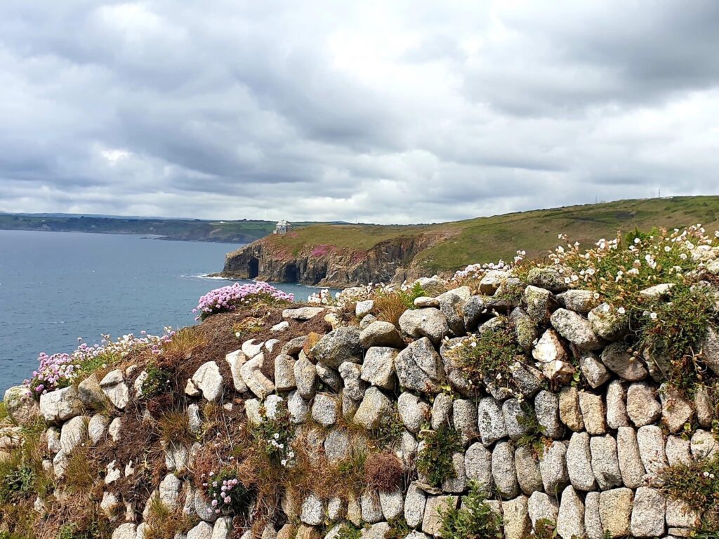
The key landscape characteristics of this section of Cornwall National Landscape are the variety of coastal scenery due to the diverse geology including hard greenstones, which form the elevated headlands as seen at Trevose Head and Stepper Point. The more easily eroded slates and shales back the bays and coves between the headlands as can be seen at Harlyn Bay, Trevone, Treyarnon and Mother Ivey’s Bay. There are extensive coastal sand dunes at Constantine Bay.


This section of the AONB is on the north coast, running south from Stepper Point near Padstow and the mouth of the Camel Estuary to Bedruthan. It is bounded to the east by the B3276 running inland between Porthcothan and Padstow.
| AONB Section | Cornwall's Landscape Character areas | Marine Character Areas covering the coast/adjacent waters |
|---|---|---|
|
CA19: Trevose Head and Coastal Plateau CA34: Camel Estuary |
MCA 45: Port Gaverne Bay to St Ives Bay |
The Key Landscape Characteristics of this section of the AONB are the variety of coastal scenery due to the diverse geology including hard greenstones, which form the elevated headlands as seen at Trevose Head and Stepper Point.
The more easily eroded slates and shales back the bays and coves between the headlands as can be seen at Harlyn Bay, Trevone, Treyarnon and Mother Ivey’s Bay. There are extensive coastal sand dunes at Constantine Bay.


The National Trust manages the west facing coastal land at Porthcothan Bay, Park Head, Trevose Head and Bedruthan Steps.

There is evidence of prehistoric features in this section which add diversity and form to the landscape. These include dramatic cliff castles south of Treyarnon Bay and barrows on Catacleuse Point.


• The Bedruthan Steps to Park Head SSSI includes a significant part of the AONB coast.
• Carnewas was awarded ‘Dark Sky Discovery’ status in recognition of the lack of light pollution in this area.

State of the AONB Report 2021
The Monumental Improvement project will ensure that 38 Scheduled Monuments in the Cornwall National Landscape will be better identified, supported and enjoyed by a wide range of communities and visitors.
High above the crashing waves, projecting west into the Atlantic are the remains of Redcliff Cliff Castle. This Iron Age stronghold is full of mystery, history and wild beauty.

Hidden among the dunes at Constantine Bay, the ruins of St Constantine’s Chapel and its nearby holy well tell a long-lost story of faith, community and care that stretches back hundreds of years.

Winecove Cliff Castle is an Iron Age monument, consisting of three dramatic promontories between Winecove Point, Pepper Cove and Warren Cove.

The Cornwall Farmland Bird Project set out to address the long-term decline of farmland birds by pairing detailed on‑farm bird surveys with practical, bespoke habitat advice. Many farmland species have…

About the monument Located at Trevose Golf & Country Club on Trevose Head in Section 04 of Cornwall National Landscape (Trevose Head to Stepper Point), St Constantine’s Chapel is the…
The policies and objectives below are applicable to this Local Section – they should, however, be read in conjunction with the Cornwall AONB Strategy Aims, Policies and Objectives which are applicable to the whole designation.
Seek restoration of the quiet rural character of locally distinctive lanes, by reduced signage, lighting, noise and by traffic reduction measures, for example, better routing for touring coaches and commercial vehicles and seek a reduction in car parking provision close to the coast
References to the main aims, policies & objectives
Seek the conservation and enhancement of the undeveloped character of the coast throughout this section and including all settlements and keep free from uncharacteristic intrusive development and tall structures, recognising the risk of cumulative effects of individual replacement dwellings.
References to the main aims, policies & objectives
 Policy LS-P1
Policy LS-P2
Policy LS-P3
Policy LS-P4
Policy LS-P6
Objective LS-Ob1
Objective LS-Ob2
Objective LS-Ob3
Objective LS-Ob4
Objective LS-Ob5
Objective LS-Ob6
Policy LS-P1
Policy LS-P2
Policy LS-P3
Policy LS-P4
Policy LS-P6
Objective LS-Ob1
Objective LS-Ob2
Objective LS-Ob3
Objective LS-Ob4
Objective LS-Ob5
Objective LS-Ob6
 Objective NRLM-Ob3
Objective NRLM-Ob9
Objective NRLM-Ob10
Objective NRLM-Ob11
Objective NRLM-Ob3
Objective NRLM-Ob9
Objective NRLM-Ob10
Objective NRLM-Ob11
 Objective CCBR-Ob4
 Objective HC-Ob1
Objective HC-Ob4
Objective HC-Ob14
Policy RSA-P1
Objective RSA-Ob1
Objective RSA-Ob2
Objective RSA-Ob4
Objective RSA-Ob5
Objective HWB-Ob2
Objective HWB-Ob5
Policy SCE-P2
Policy SCE-P3
Policy SCE-P5
Policy SCE-P6
Objective SCE-Ob1
Objective SCE-Ob2
Objective SCE-Ob4
Objective SCE-Ob5
Policy PD-P1
Policy PD-P2
Policy PD-P3
Policy PD-P7
Policy PD-P12
Policy PD-P18
Objective HC-Ob1
Objective HC-Ob4
Objective HC-Ob14
Policy RSA-P1
Objective RSA-Ob1
Objective RSA-Ob2
Objective RSA-Ob4
Objective RSA-Ob5
Objective HWB-Ob2
Objective HWB-Ob5
Policy SCE-P2
Policy SCE-P3
Policy SCE-P5
Policy SCE-P6
Objective SCE-Ob1
Objective SCE-Ob2
Objective SCE-Ob4
Objective SCE-Ob5
Policy PD-P1
Policy PD-P2
Policy PD-P3
Policy PD-P7
Policy PD-P12
Policy PD-P18
Encourage the enhancement of the coast and settlements around Constantine Bay, St Merryn, Mother Ivey’s Bay, Harlyn, Porthcothan, Treyarnon and Trevone, towards having a more undeveloped character.
References to the main aims, policies & objectives
Policy LS-P1
Policy LS-P2
Policy LS-P3
Policy LS-P4
Policy LS-P6
Objective LS-Ob1
Objective LS-Ob2
Objective LS-Ob3
Objective LS-Ob6
Objective NRLM-Ob9
Objective NRLM-Ob11
Objective NRLM-Ob13
Policy CCBR-P1
Objective CCBR-Ob2
Objective CCBR-Ob4
Objective HC-Ob1
Objective HC-Ob4
Objective HC-Ob11
Policy RSA-P1
Policy RSA-P2
Policy RSA-P3
Objective RSA-Ob4
Objective RSA-Ob5
Objective HWB-Ob2
Objective HWB-Ob3
Objective HWB-Ob5
Policy SCE-P2
Policy SCE-P3
Policy SCE-P5
Policy SCE-P6
Policy SCE-P7
Objective SCE-Ob1
Objective SCE-Ob2
Objective SCE-Ob3
Objective SCE-Ob4
Objective SCE-Ob5
Policy PD-P12
Policy PD-P18
Seek a reduction of landscape, car parking and visual impacts of tourism including better integration of existing holiday sites and visitor infrastructure. Have regard to increase in scale, massing, associated development and respecting local character, landscape capacity and sensitivity in external works, landscaping, and site design for example at Mother Ivey’s Bay, Harlyn, Porthcothan and Treyarnon.
References to the main aims, policies & objectives
Policy LS-P1
Policy LS-P2
Policy LS-P3
Policy LS-P4
Policy LS-P6
Objective LS-Ob6
Objective NRLM-Ob11
Policy RSA-P1
Policy RSA-P2
Policy RSA-P4
Objective RSA-Ob1
Objective RSA-Ob2
Objective RSA-Ob4
Objective RSA-Ob5
Policy SCE-P2
Policy SCE-P3
Policy SCE-P5
Policy SCE-P6
Objective SCE-Ob1
Objective SCE-Ob5
Policy PD-P9
Seek to maintain the current low levels of light pollution across the section, in order to maintain dark night skies and to support the ‘Dark Sky Discovery’ area at Carnewas.
References to the main aims, policies & objectives
Support a local partnership approach including the local community, parish councils, farmers, landowners, stakeholders and agencies to better manage the competing demands that impact on the rich natural environment and natural beauty of the section.
References to the main aims, policies & objectives
Policy LS-P1
Policy LS-P2
Policy LS-P3
Policy LS-P4
Policy LS-P5
Policy LS-P6
Objective LS-Ob1
Objective LS-Ob2
Objective LS-Ob3
Objective LS-Ob4
Objective LS-Ob5
Objective LS-Ob6
Objective NRLM-Ob1
Objective NRLM-Ob2
Objective NRLM-Ob3
Objective NRLM-Ob5
Objective NRLM-Ob6
Objective NRLM-Ob8
Objective NRLM-Ob9
Objective NRLM-Ob10
Objective NRLM-Ob11
Objective NRLM-Ob12
Objective NRLM-Ob13
Policy CCBR-P1
Objective CCBR-Ob1
Objective CCBR-Ob2
Objective CCBR-Ob3
Objective CCBR-Ob4
Objective CCBR-Ob5
Objective HC-Ob11
Objective HC-Ob4
Objective HC-Ob12
Objective HC-Ob13
Policy RSA-P1
Policy RSA-P2
Policy RSA-P3
Objective RSA-Ob1
Objective RSA-Ob2
Objective RSA-Ob5
Objective HWB-Ob2
Objective HWB-Ob3
Objective HWB-Ob5
Policy SCE-P2
Policy SCE-P3
Policy SCE-P4
Policy SCE-P5
Policy SCE-P6
Objective SCE-Ob1
Objective SCE-Ob2
Objective SCE-Ob3
Objective SCE-Ob4
Objective SCE-Ob5
Objective SCE-Ob6
Objective SCE-Ob7
Help to support coastal management, which promotes natural processes wherever possible and support initiatives with communities that consider the long-term future of coastal areas e.g. Harlyn Bay in respect to predicted effects of sea level rise and increased storminess. Seek to support the delivery of appropriate measures to ‘hold the line’ and ‘managed realignment’ as identified in the shoreline management plan where they conserve or enhance the landscape character and natural beauty of the AONB.
References to the main aims, policies & objectives
Seek improved management of coastal habitats via appropriate measures such as grazing.
References to the main aims, policies & objectives
Policy LS-P1
Objective LS-Ob1
Objective LS-Ob2
Objective LS-Ob3
Objective LS-Ob4
Objective NRLM-Ob1
Objective NRLM-Ob3
Objective NRLM-Ob5
Objective NRLM-Ob9
Objective NRLM-Ob13
Objective CCBR-Ob1
Objective CCBR-Ob2
Objective CCBR-Ob4
Objective HWB-Ob2
Objective HWB-Ob5
Objective SCE-Ob1
Objective SCE-Ob4
Support, through a landscape scale approach, measures to restore and connect local habitats and to increase their protection from visitor pressures. These include reed beds and rivers; lowland meadows; coastal heath and rough ground; maritime cliffs and slopes; lowland heathland and coastal sand dunes, such as at Constantine Bay.
References to the main aims, policies & objectives
Related topics and useful links
The Management Plan is a shared strategy for those who live, work and visit the Cornwall Area of Outstanding Natural Beauty.
The Monumental Improvement project has ensured that 40 Scheduled Monuments in the Cornwall National Landscape have been better identified, supported and enjoyed by a wide range of communities and visitors.