Monitoring & Evidence
Our objectives can be achieved through various means such as but not...
View page

The key landscape characteristics of the coastal landscape in this area of Cornwall National Landscape is a soft profile. It benefits from the protection offered by the Penwith peninsula against the full force of the Atlantic storms. The iconic rocky granite intrusion of St Michael’s Mount dominates Mount’s Bay with its cobbled granite causeway leading out to the Mount at low tide.
The Lizard coast has tall cliffs with small coves beneath. It is the most southerly point of mainland Britain where the distinctive towers of the Lizard Lighthouse warn of the hazardous waters off Lizard Point.
The Helford River is an area of great individual character and tranquil beauty. Rounded landforms slope to deep, narrow valleys with dense woodland of predominately sessile oak and it is one of the few places in England were the ancient woodland meets the sea. The romanticism and ambience of the river with its hidden creeks provided a perfect setting for the famous Daphne Du Maurier novel, Frenchman’s Creek.


This section of the AONB is large, wide-ranging and diverse, extending from Marazion in the west to the outskirts of Falmouth (Maenporth) in the east and includes the entire Lizard Peninsula and the Helford Estuary.
| AONB Section | Cornwall's Landscape Character areas | Marine Character Areas covering the coast/adjacent waters |
|---|---|---|
|
CA06: Mount’s Bay East CA07: South Lizard Peninsula CA08: North East Lizard Peninsula CA09: Helford Ria |
MCA 48: Mount’s Bay and The Lizard MCA 49: South Cornwall Coastal Waters and Estuaries |
The key landscape characteristics of the coastal landscape in this area of the AONB is a soft profile. It benefits from the protection offered by the Penwith peninsula against the full force of the Atlantic storms. The iconic rocky granite intrusion of St Michael’s Mount dominates Mount’s Bay with its cobbled granite causeway leading out to the Mount at low tide.


The key landscape characteristics of the Lizard coast are tall cliffs with small coves beneath. It is the most southerly point of mainland Britain where the distinctive towers of the Lizard Lighthouse warn of the hazardous waters off Lizard Point.
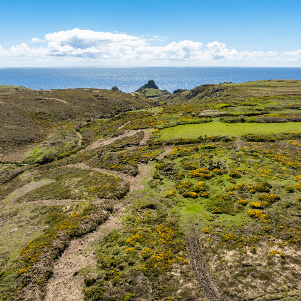
The geological variations of this peninsula have resulted in complex landforms. Inland of Gunwalloe and Mullion Cove there is a soft, undulating landscape spread over Devonian rocks with farmsteads and small hamlets interspersed with streams which reach the coast at Church Cove and Poldhu Cove. There are small pockets of woodlands on farms and these become more extensive north-eastwards to the head of the Helford Estuary. The elevated south west plateau of the Lizard Peninsula is underlain with serpentine as can be seen from the outcrops at Kynance Cove. The landform to the east falls gently on the gabbro and hornblende schists toward the coast and is permeated with small streams, which have formed sheltered valleys along weaknesses in the rock.
The combination of geology, mild oceanic climate conditions and its southerly location has led to the development of a unique range of habitats with many rare species of local and national importance. There are significant areas of heathland/ plateau rough ground across Goonhilly Downs and on the west coast that are critically important from both historic and biodiversity perspectives. The Lizard National Nature Reserve stretches across nearly 2,000 hectares of the peninsula. The heathland, coastal cliff vegetation and temporary ponds are of international importance and accommodate a broad diversity of wildlife which thrives here, including especially rare and unusual plants. The wild, open nature of these expansive habitats is emphasised by the lack of tree cover with the exception of those found in the sheltered valleys and coves.

The key landscape characteristics of this area is a marked contrast to the landscape of the Lizard Peninsula, the Helford River is an area of great individual character and tranquil beauty. Rounded landforms slope to deep, narrow valleys with dense woodland of predominately sessile oak and it is one of the few places in England were the ancient woodland meets the sea. The romanticism and ambience of the river with its hidden creeks provided a perfect setting for the famous Daphne Du Maurier novel, Frenchman’s Creek.
The seaward opening of the Helford River is marked by Nare Point to the south and Rosemullion Head to the north. The shallow angled cliffs of the river mouth exposed to the open sea of Falmouth Bay continue to support areas of coastal heathland whilst the steeper cliff face near Mawnan Church and higher, has a diversity of woodland species including mature ilex oaks and Monterey pines.
Although there are no large settlements within the Helford River area there are many scattered smaller ones with villages clustered around the creek heads and crossroads such as at Mawnan Smith, the landscape still retaining the traditional settlement pattern of scattered rural farming hamlets. Some, like Manaccan and St Martin, with medieval churches at their heart. At the mouth of the estuary, St Anthony Church nestles in the shelter of Dennis Head, defended by prominent earthworks in both the Iron Age and English Civil War. The village of Gweek at the head of the Helford Estuary was once an ancient tin mining port possibly used during the early Iron Age. The recent and ongoing development at the boatyard which dominates the head of the creek has the potential to change its character.

The following information is relevant to all three ‘South Coast Western’ local sections: St Michael’s Mount to Halzephron Cliff; the Lizard Peninsula; and the Helford River.
The National Trust manages significant land and property around the coast from St Michael’s Mount, Rinsey, Penrose Estate, Mullion and Poldhu, Predannack and Kynance, Lizard Point, Cadgwith to Poltesco and Coverack as well as the land to the south and north of the Helford. The National Trust grazing schemes exist to tackle scrub encroachment on coastal heathland.
Cornwall Wildlife Trust own and manage Windmill Farm Local Nature Reserve and have recently restored the historic stone windmill structure to include a small interpretation centre and viewing platform.
Natural England, alongside Cornwall Wildlife Trust, National Trust and Cornwall Bird Watching and Preservation Society, manage the Lizard National Nature Reserve which includes much of Goonhilly Downs.
Trelowarren is a large private estate on the Lizard.


State of the AONB Report 2021
The Monumental Improvement project will ensure that 38 Scheduled Monuments in the Cornwall National Landscape will be better identified, supported and enjoyed by a wide range of communities and visitors.
A quiet spot on Goonhilly Downs hides six ancient burial mounds, right next to the giant satellite dishes.
Dotted across Goonhilly Downs are the remains of large Bronze Age funerary monuments called Barrows.

Along the coast between Coverack and Lowland point is a hidden gem of Cornwall’s prehistoric past. This scheduled monument includes multi-period settlements, field systems and manufacturing sites along the coast edge and extending inland. A lot of the site is difficult to reach and on private land, however just off the coast path on the cliff edge is the remains of a Romano-British Salt Working Site.

Perched between two coves on Cornwall’s wild south coast, Gunwalloe Cliff Castle is a recently discovered gem from Prehistoric Cornwall. Its dramatic yet beautiful setting and long history make it a fascinating place to explore, where ancient ramparts meet sea views and stories of shipwrecks and treasure still stir the imagination.

Hidden among the rocks and rare Golden Hair lichen, Kynance Gate is made up of two clusters of roundhouses. Altogether, there are at least 21 houses that tell the story of people living and working here thousands of years ago. From farming animals to making tools and pottery, this ancient village shows how closely people lived with the wild landscape around them.

The Kynance Gate ancient settlement, located on the Lizard Peninsula in Cornwall, is a significant archaeological site dating back to the Bronze and Iron Ages. Despite its historical importance, the…

About the Monument Kynance Gate is a Prehistoric settlement site consisting of 2 discreet groups of Roundhouses. Located on the Lizard Peninsula, this monument sits within Section 8 of Cornwall…
The policies and objectives below are applicable to this Local Section – they should, however, be read in conjunction with the Cornwall AONB Strategy Aims, policies and Objectives which are applicable to the whole designation.
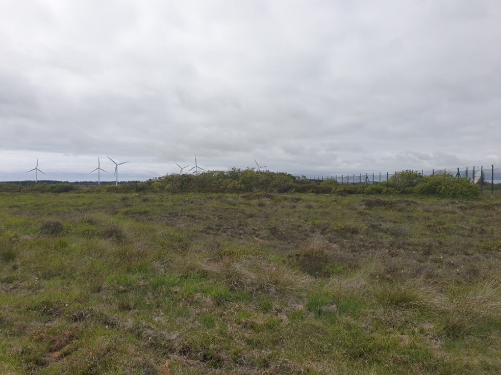
Seek, wherever possible, a reduction in the visual and landscape impact of the dishes, associated infrastructure and light pollution at the Goonhilly Earth Station and light pollution from RNAS Culdrose (outside the AONB). Ensure that the ongoing and future proposals for alternative uses/ redevelopment of the Earth Station do not have an adverse visual or landscape character impact and bring social and economic benefits to the local community.
References to the main aims, policies & objectives
Any new proposals for mineral extraction and quarrying, such as at Dean Quarry, that adversely impact upon the scenic beauty, special qualities, landscape character and tranquillity of this section of the AONB, and the Manacles Marine Conservation Zone, will not be supported.
References to the main aims, policies & objectives
Support improved phased and final restoration at West of England quarry to final landforms and vegetation communities consistent with local landscape character including at the earliest possible stages permanent, appropriate restoration along coast path routes and completed working areas. Support further measures to protect and enhance environmental quality when existing quarrying permissions are reviewed.
References to the main aims, policies & objectives
Support the characteristic inclusion of local materials and vernacular design in new development, public realm, highways work, and public rights of way infrastructure using granite, serpentine, gabbro and schists as appropriate to reflect the varied geodiversity of this section.
References to the main aims, policies & objectives
 Policy LS-P1
Policy LS-P2
Policy LS-P6
Objective LS-Ob4
Policy LS-P1
Policy LS-P2
Policy LS-P6
Objective LS-Ob4
 Objective NRLM-Ob10
Objective NRLM-Ob11
Objective NRLM-Ob10
Objective NRLM-Ob11
 Objective HC-Ob1
Objective HC-Ob4
Objective HC-Ob8
Objective HC-Ob12
Objective HC-Ob15
Policy RSA-P1
Policy RSA-P2
Objective RSA-Ob1
Objective RSA-Ob2
Objective RSA-Ob4
Objective HWB-Ob1
Objective HWB-Ob2
Objective HWB-Ob3
Objective HWB-Ob4
Objective HWB-Ob5
Objective HC-Ob1
Objective HC-Ob4
Objective HC-Ob8
Objective HC-Ob12
Objective HC-Ob15
Policy RSA-P1
Policy RSA-P2
Objective RSA-Ob1
Objective RSA-Ob2
Objective RSA-Ob4
Objective HWB-Ob1
Objective HWB-Ob2
Objective HWB-Ob3
Objective HWB-Ob4
Objective HWB-Ob5
 Policy SCE-P3
Policy SCE-P6
Objective SCE-Ob1
Objective SCE-Ob5
Policy SCE-P3
Policy SCE-P6
Objective SCE-Ob1
Objective SCE-Ob5
Support appropriate improvements to coastal footpath access between Godrevy Cove and Porthallow provided that this respects local landscape character and conserves and enhances natural beauty, provided that this does not impact upon the qualifying features of the Fal & Helford SAC from recreational disturbance.
References to the main aims, policies & objectives
Policy LS-P1
Policy LS-P2
Policy LS-P3
Objective LS-Ob6
Objective NRLM-Ob9
Objective CCBR-Ob4
Policy RSA-P1
Policy RSA-P2
Policy RSA-P3
Objective RSA-Ob1
Objective RSA-Ob2
Objective RSA-Ob3
Objective RSA-Ob4
Objective HWB-Ob1
Objective HWB-Ob2
Objective HWB-Ob3
Objective HWB-Ob4
Objective HWB-Ob5
Policy SCE-P3
Policy SCE-P6
Objective SCE-Ob1
Objective SCE-Ob5
Support the continuation of small-scale sustainable fisheries in order to maintain community vibrancy providing that it enhances local character and conserves natural assets, for example at local coves such as at Porthleven, Mullion, Cadgwith, Coverack, Porthoustock, Porthallow and within the creeks of the Helford Estuary (provided that this does not impact upon the special features of the Special Area of Conservation).
References to the main aims, policies & objectives
Support the conservation and positive management of mining features that are outside of the World Heritage Site, south of the A394 around Perranuthnoe, Rosudgeon, Kennegy, Praa Sands and Porthleven.
References to the main aims, policies & objectives
Policy LS-P1
Policy LS-P2
Policy LS-P4
Policy LS-P6
Objective LS-Ob4
Objective HC-Ob1
Objective HC-Ob4
Objective HC-Ob6
Objective HC-Ob7
Objective HC-Ob9
Objective HC-Ob11
Objective HC-Ob12
Objective HC-Ob13
Objective HC-Ob14
Objective HC-Ob15
Objective RSA-Ob3
Objective RSA-Ob4
Objective HWB-Ob3
Policy SCE-P6
Objective SCE-Ob1
Objective SCE-Ob2
Support enhancement of the wider setting of St Michael’s Mount including sea front car parking by design changes to layout, location, minimising infrastructure, enhanced boundary treatments, characteristic use of local materials in external works and appropriate vegetation.
References to the main aims, policies & objectives
Policy LS-P1
Policy LS-P2
Policy LS-P3
Policy LS-P6
Objective LS-Ob4
Objective LS-Ob6
Objective NRLM-Ob1
Objective NRLM-Ob5
Objective NRLM-Ob10
Objective NRLM-Ob11
Objective NRLM-Ob12
Objective HC-Ob1
Objective HC-Ob4
Objective HC-Ob8
Policy RSA-P1
Policy RSA-P2
Objective RSA-Ob4
Objective RSA-Ob5
Objective HWB-Ob2
Objective HWB-Ob5
Policy SCE-P3
Policy SCE-P5
Policy SCE-P6
Objective SCE-Ob1
Objective SCE-Ob2
Objective SCE-Ob5
Policy PD-P9
Support conservation and enhancement of the character of the open heathland plateau including reduction of visual and landscape impacts from existing conifer plantations on Goonhilly Downs consistent with best practice
References to the main aims, policies & objectives
Seek reduction of landscape and visual impacts of tourism including better integration of existing holiday sites, visitor infrastructure, car parks and signage. Pay particular attention to respecting local character in external works, landscaping and site design and have particular regard to increase in scale, massing and cumulative development for example at Marazion, Perranuthnoe, Porthleven, Praa Sands, Mullion and Kennack Sands.
References to the main aims, policies & objectives
Policy LS-P1
Policy LS-P2
Policy LS-P3
Policy LS-P6
Objective LS-Ob6
Objective NRLM-Ob11
Objective HC-Ob4
Objective HC-Ob11
Objective HC-Ob15
Policy RSA-P1
Policy RSA-P2
Policy RSA-P4
Policy RSA-P5
Objective RSA-Ob4
Objective RSA-Ob5
Objective HWB-Ob5
Policy SCE-P2
Policy SCE-P3
Policy SCE-P5
Policy SCE-P6
Objective SCE-Ob1
Objective SCE-Ob5
Policy PD-P9
Seek a reduction in the visual impact of overhead cables by undergrounding in affected villages for example Porthleven, Mullion, St Keverne, Lizard, Gweek and Cury.
References to the main aims, policies & objectives
Support the Linking the Lizard Partnership in it
initiatives to integrate land management, farming and the conservation of biodiversity and historic environment together with the promotion of a vibrant local rural economy and community.
References to the main aims, policies & objectives
Policy LS-P1
Policy LS-P2
Policy LS-P3
Policy LS-P4
Policy LS-P6
Objective LS-Ob1
Objective LS-Ob2
Objective LS-Ob3
Objective LS-Ob4
Objective LS-Ob5
Objective LS-Ob6
Objective NRLM-Ob1
Objective NRLM-Ob2
Objective NRLM-Ob3
Objective NRLM-Ob5
Objective NRLM-Ob6
Objective NRLM-Ob9
Objective NRLM-Ob10
Objective NRLM-Ob11
Objective NRLM-Ob12
Objective NRLM-Ob13
Policy CCBR-P1
Objective CCBR-Ob1
Objective CCBR-Ob2
Objective CCBR-Ob3
Objective CCBR-Ob4
Objective CCBR-Ob5
Objective HC-Ob1
Objective HC-Ob3
Objective HC-Ob4
Objective HC-Ob6
Objective HC-Ob7
Objective HC-Ob8
Objective HC-Ob9
Objective HC-Ob10
Objective HC-Ob11
Objective HC-Ob12
Objective HC-Ob13
Objective HC-Ob14
Policy RSA-P1
Policy RSA-P2
Policy RSA-P3
Policy RSA-P4
Objective RSA-Ob1
Objective RSA-Ob2
Objective RSA-Ob3
Objective RSA-Ob4
Objective RSA-Ob5
Objective HWB-Ob1
Objective HWB-Ob2
Objective HWB-Ob3
Objective HWB-Ob4
Objective HWB-Ob5
Policy SCE-P2
Policy SCE-P3
Policy SCE-P4
Policy SCE-P5
Policy SCE-P6
Policy SCE-P7
Objective SCE-Ob1
Objective SCE-Ob2
Objective SCE-Ob3
Objective SCE-Ob4
Objective SCE-Ob6
Help to support coastal management which promotes natural processes wherever possible and support initiatives with communities which consider the long term future and value of coastal areas e.g. Mullion Cove, Marazion, Mounts Bay, Porthleven, Loe Bar, Praa Sands, Gweek, Cadgwith, Coverack, and Maenporth in respect to predicted effects of sea level rise and increased storminess. Seek to support the delivery of appropriate measures to hold the line where infrastructure such as sewage outfalls and roads need to be protected. Manage realignmen as identified in the Shoreline Management Plan where they conserve or enhance the landscape character and natural beauty of the AONB. Conserve the undeveloped nature of the coast in this section.
References to the main aims, policies & objectives
Policy LS-P1
Policy LS-P2
Policy LS-P3
Policy LS-P4
Objective LS-Ob1
Objective LS-Ob2
Objective LS-Ob3
Objective LS-Ob6
Objective NRLM-Ob9
Objective NRLM-Ob11
Policy CCBR-P1
Objective CCBR-Ob4
Objective CCBR-Ob5
Objective HC-Ob4
Policy RSA-P1
Objective RSA-Ob4
Objective HWB-Ob5
Policy SCE-P3
Policy SCE-P6
Objective SCE-Ob1
Objective SCE-Ob4
Objective SCE-Ob5
Support the work of the Loe Pool Forum and encourage measures to improve water and habitat quality at Loe Pool and in the Helford
References to the main aims, policies & objectives
Support measures to improve water and habitat quality in the Helford by supporting measures to reduce run off and nitrate input.
References to the main aims, policies & objectives
Objective NRLM-Ob1
Objective NRLM-Ob2
Objective NRLM-Ob3
Objective NRLM-Ob5
Objective NRLM-Ob6
Objective NRLM-Ob9
Objective NRLM-Ob12
Objective NRLM-Ob13
Policy CCBR-P1
Objective CCBR-Ob1
Objective CCBR-Ob2
Objective CCBR-Ob3
Objective CCBR-Ob4
Objective CCBR-Ob5
Objective HWB-Ob5
Objective SCE-Ob2
Objective SCE-Ob4
Support the Helford Marine Conservation Group and the continuation of the Helford Voluntary Marine Conservation Area to encourage engagement and involvement in enjoyment and sensitive use of the Helford Estuary Special Area of Conservation.
References to the main aims, policies & objectives
Related topics and useful links
The Management Plan is a shared strategy for those who live, work and visit the Cornwall Area of Outstanding Natural Beauty.
Further details on the Monument Improvement Project