Monitoring & Evidence
Our objectives can be achieved through various means such as but not...
View page

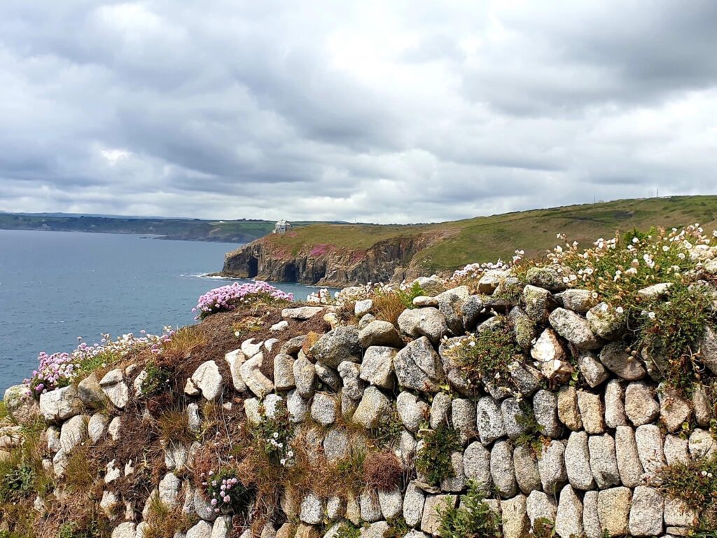
The key landscape characteristics of this section of Cornwall National Landscape are its sheer cliffs of unstable, soft, gritty slate – constantly eroded by the unrelenting power of the Atlantic Ocean, as seen at Hell’s Mouth and Hudder Cove and are referred to as ‘North Cliffs’. In stark contrast, just inland, the terrain turns from coastal heath to more recently enclosed farmland and further on to a quiet wooded valley.


The coast of this AONB section contains some dramatic scenery and extends from north of Camborne between the higher ground of Navax Point in the west, to the lower Tregea Hill, extending from Portreath in the east to the Red River to the south and west.
| AONB Section | Cornwall's Landscape Character areas | Marine Character Areas covering the coast/adjacent waters |
|---|---|---|
|
CA11: Redruth, Camborne and Gwennap CA28: North Coast- Reskeage Downs |
MCA 45: Port Gaverne Bay to St Ives Bay |
The Key Landscape Characteristics of this section of the AONB are its sheer cliffs of unstable, soft, gritty slate – constantly eroded by the unrelenting power of the Atlantic Ocean, as seen at Hell’s Mouth and Hudder Cove and are referred to as ‘North Cliffs’. In stark contrast, just inland, the terrain turns from coastal heath to more recently enclosed farmland and further on to a quiet wooded valley.


The AONB coastline is included in the Godrevy Head to St Agnes SSSI.

State of the AONB Report 2021
The Monumental Improvement project will ensure that 38 Scheduled Monuments in the Cornwall National Landscape will be better identified, supported and enjoyed by a wide range of communities and visitors.
Welcome to Tehidy Round – a place where people farmed, built homes and lived together over 2,000 years ago, long before the trees you see today were here.

Perched high above the sea near Illogan, Carvannel Cliff Castle is one of Cornwall’s ancient promontory forts. Even though not much remains, its clifftop location tells a story of people living and defending this dramatic stretch of coast over 2,000 years ago.


The Red River Valley in Cornwall, once known as the most polluted river in the region due to its mining legacy, is now a focal point for environmental restoration. The…

About the Monument Tehidy Round is located in Section 6 (Godrevy to Portreath) of Cornwall National Landscape, north-west of Redruth, in the parish of Illogan. It is situated on level…
The policies and objectives below are applicable to this Local Section – they should, however, be read in conjunction with the Cornwall AONB Strategy Aims, Policies and Objectives which are applicable to the whole designation.
Seek measures for the enhancement of the appearance of visitor developments and their setting at Godrevy and Hell’s Mouth consistent with local vernacular for example, including use of locally characteristic Cornish killas in hedging and walling and granite detailing
References to the main aims, policies & objectives
 Policy LS-P1
Policy LS-P2
Policy LS-P4
Policy LS-P6
Objective LS-Ob4
Objective LS-Ob6
Policy LS-P1
Policy LS-P2
Policy LS-P4
Policy LS-P6
Objective LS-Ob4
Objective LS-Ob6
 Objective HC-Ob2
Objective HC-Ob4
Objective HC-Ob8
Objective HC-Ob11
Objective HC-Ob12
Objective HC-Ob14
Policy RSA-P1
Policy RSA-P2
Policy RSA-P3
Objective RSA-Ob3
Objective RSA-Ob4
Objective HWB-Ob2
Objective HWB-Ob6
Objective HC-Ob2
Objective HC-Ob4
Objective HC-Ob8
Objective HC-Ob11
Objective HC-Ob12
Objective HC-Ob14
Policy RSA-P1
Policy RSA-P2
Policy RSA-P3
Objective RSA-Ob3
Objective RSA-Ob4
Objective HWB-Ob2
Objective HWB-Ob6

 Policy SCE-P3
Policy SCE-P5
Policy SCE-P6
Objective SCE-Ob1
Objective SCE-Ob2
Objective SCE-Ob5
Policy PD-P9
Policy PD-P14
Policy SCE-P3
Policy SCE-P5
Policy SCE-P6
Objective SCE-Ob1
Objective SCE-Ob2
Objective SCE-Ob5
Policy PD-P9
Policy PD-P14
Seek protection of undeveloped and sparsely settled rural character and open views, free of tall structures. Seek a reduction in the visual impact of overhead cables by undergrounding, for example along the B3301.
References to the main aims, policies & objectives
Policy LS-P1
Policy LS-P2
Policy LS-P3
Policy LS-P4
Policy LS-P6
Objective LS-Ob1
Objective LS-Ob2
Objective LS-Ob3
Objective LS-Ob6
Objective HC-Ob1
Objective HC-Ob4
Objective HC-Ob11
Policy RSA-P1
Objective RSA-Ob4
Objective RSA-Ob5
Policy SCE-P3
Policy SCE-P5
Policy SCE-P6
Objective SCE-Ob1
Objective SCE-Ob5
Policy PD-P1
Policy PD-P2
Policy PD-P3
Policy PD-P7
Policy PD-P11
Policy PD-P12
Policy PD-P18
Support the review of access to Godrevy Point in light of the anticipated future severance of the access road by the sea and restore the headland to natural coastal habitats.
References to the main aims, policies & objectives
Policy LS-P1
Policy LS-P2
Objective LS-Ob1
Objective LS-Ob2
Objective LS-Ob3
Objective LS-Ob6
Objective NRLM-Ob1
Objective NRLM-Ob3
Objective NRLM-Ob5
Objective NRLM-Ob10
Objective NRLM-Ob12
Objective NRLM-Ob13
Objective CCBR-Ob1
Objective CCBR-Ob4
Objective CCBR-Ob5
Policy RSA-P2
Objective RSA-Ob1
Objective RSA-Ob5
Policy SCE-P3
Policy SCE-P6
Objective SCE-Ob1
Objective SCE-Ob4
Support improvement in the landscape integration of all locations used for visitor car parking including those at Godrevy and along the B3301 and North Cliffs.
References to the main aims, policies & objectives
Policy LS-P1
Policy LS-P2
Policy LS-P4
Policy LS-P6
Objective LS-Ob4
Objective LS-Ob6
Objective HC-Ob2
Objective HC-Ob4
Objective HC-Ob8
Objective HC-Ob11
Objective HC-Ob12
Objective HC-Ob14
Objective HC-Ob15
Policy RSA-P1
Policy RSA-P2
Policy RSA-P3
Objective RSA-Ob3
Objective RSA-Ob4
Objective HWB-Ob2
Objective HWB-Ob6
Policy SCE-P3
Policy SCE-P5
Policy SCE-P6
Objective SCE-Ob1
Objective SCE-Ob2
Objective SCE-Ob5
Support use of locally characteristic slate in new stiles and steps and other rights of way works in a manner consistent for example with those found near Godrevy Point in order to reinforce local character along the coast path and other footpaths. Consider new design solutions that enhance access for those with mobility impairments.
References to the main aims, policies & objectives
Support the growth of Portreath to meet local needs in ways that do not adversely impact the AONB and its setting and prevent further development harming the AONB through its scale, siting, design, massing and materials.
References to the main aims, policies & objectives
Seek the conservation and enhancement of the rura character of all lanes and roads including the B3301 through the retention of hedges, narrow winding character and low levels of signage.
References to the main aims, policies & objectives
Policy LS-P1
Policy LS-P2
Policy LS-P3
Policy LS-P6
Objective LS-Ob4
Objective LS-Ob6
Objective NRLM-Ob10
Objective NRLM-Ob11
Objective HC-Ob1
Objective HC-Ob4
Objective HC-Ob8
Objective HC-Ob11
Objective HC-Ob12
Policy RSA-P1
Objective RSA-Ob4
Objective RSA-Ob5
Objective HWB-Ob5
Policy SCE-P3
Policy SCE-P6
Objective SCE-Ob1
Objective SCE-Ob2
Objective SCE-Ob5
Increase awareness and promote a sense of connection and responsibility for the AONB among the communities of nearby settlements including Camborne, Pool, Redruth, Illogan, Hayle, and Portreath.
References to the main aims, policies & objectives
Policy LS-P1
Objective LS-Ob6
Objective HC-Ob2
Objective HC-Ob4
Objective HC-Ob11
Objective HC-Ob13
Policy RSA-P1
Policy RSA-P2
Policy RSA-P4
Objective RSA-Ob1
Objective RSA-Ob2
Objective RSA-Ob3
Objective HWB-Ob1
Objective HWB-Ob2
Objective HWB-Ob3
Objective HWB-Ob4
Objective HWB-Ob5
Objective SCE-Ob5
Objective SCE-Ob6
Support the work of the Towans Partnership and the delivery of the objectives of the Towans Management Plan where these support the purposes of the AONB designation.
References to the main aims, policies & objectives
Policy LS-P1
Policy LS-P2
Policy LS-P4
Objective LS-Ob1
Objective LS-Ob2
Objective LS-Ob3
Objective LS-Ob6
Objective NRLM-Ob1
Objective NRLM-Ob3
Objective NRLM-Ob5
Objective NRLM-Ob9
Objective NRLM-Ob12
Objective NRLM-Ob13
Policy CCBR-P1
Objective CCBR-Ob1
Objective CCBR-Ob4
Objective CCBR-Ob5
Policy RSA-P1
Policy RSA-P2
Objective RSA-Ob1
Objective HWB-Ob5
Policy SCE-P1
Policy SCE-P3
Policy SCE-P6
Objective SCE-Ob1
Objective SCE-Ob4
Objective SCE-Ob7
Help to support coastal management, which promotes natural processes wherever possible and support initiatives with communities which consider the long-term future of Portreath in respect to predicted effects of sea level rise and increased storminess. Seek to support the delivery of appropriate measures to ‘hold the line’ and ‘manage realignment’ as identified in the Shoreline Management Plan, where they conserve or enhance the landscape character and natural beauty of the AONB. Conserve the undeveloped nature of the coast away from settlements.
References to the main aims, policies & objectives
Policy LS-P1
Policy LS-P2
Policy LS-P3
Policy LS-P4
Objective LS-Ob1
Objective LS-Ob2
Objective LS-Ob3
Objective LS-Ob6
Objective NRLM-Ob9
Objective NRLM-Ob11
Policy CCBR-P1
Objective CCBR-Ob4
Objective CCBR-Ob5
Objective HC-Ob2
Objective HC-Ob4
Objective HC-Ob15
Policy RSA-P1
Objective RSA-Ob4
Objective HWB-Ob5
Policy SCE-P3
Policy SCE-P6
Objective SCE-Ob1
Objective SCE-Ob4
Objective SCE-Ob5
Support improved connectivity into the AON from Camborne, Pool and Redruth, through the provision of green infrastructure and sustainable
transport links. Include these in any proposals for urban expansion
at Camborne, Pool, Illogan, Redruth and Hayle.
References to the main aims, policies & objectives
Policy CCBR-P1
Objective CCBR-Ob5
Objective HC-Ob2
Objective HC-Ob15
Policy RSA-P1
Policy RSA-P2
Policy RSA-P3
Policy RSA-P4
Objective RSA-Ob1
Objective RSA-Ob2
Objective RSA-Ob3
Objective RSA-Ob5
Objective HWB-Ob1
Objective HWB-Ob2
Objective HWB-Ob3
Objective HWB-Ob4
Objective HWB-Ob5
Policy SCE-P3
Policy SCE-P4
Policy SCE-P6
Objective SCE-Ob1
Objective SCE-Ob3
Objective SCE-Ob5
Objective SCE-Ob6
Policy PD-P6
Related topics and useful links
The Management Plan is a shared strategy for those who live, work and visit the Cornwall Area of Outstanding Natural Beauty.
The Monumental Improvement project has ensured that 40 Scheduled Monuments in the Cornwall National Landscape have been better identified, supported and enjoyed by a wide range of communities and visitors.