Monitoring & Evidence
Our objectives can be achieved through various means such as but not...
View page
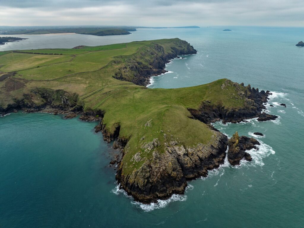
The key landscape characteristic of this section of Cornwall National Landscape is the coastline, which throughout this section is craggy with dramatic contorted cliffs and folded slates, shales and volcanic rocks with some sandstone to the north. There are also some interesting coastal features such as rocky stacks, arches, headlands, caves and blowholes interspersed with rocky coves and a few sandy beaches, such as at Trebarwith Strand and Crackington Haven. ‘High Cliff’ near Tresparrett, at 223m, is the highest sheer drop cliff in Cornwall and is formed from carboniferous sandstones and shales; the cliff line then gradually reduces in height to approximately 70-80m at Pentire Point.


The coastal strip between Pentire Point in the south and Widemouth in the north forms this section of the AONB. Inland it is bounded by the B3314 in the south and the A39 in the north.
| AONB Section | Cornwall's Landscape Character areas | Marine Character Areas covering the coast/adjacent waters |
|---|---|---|
|
CA34: Camel Estuary CA37: Western Culm Plateau CA38: Bude Basin CA35: Kellan Head to Millook Haven Coast CA36: Delabole Plateau |
MC 44: Hartland Point to Port Isaac Bay MCA 45: Port Gaverne Bay to St Ives Bay |
The Key Landscape Characteristic of this section of the AONB is the coastline, which throughout this section is craggy with dramatic contorted cliffs and folded slates, shales and volcanic rocks with some sandstone to the north.
There are also some interesting coastal features such as rocky stacks, arches, headlands, caves and blowholes interspersed with rocky coves and a few sandy beaches, such as at Trebarwith Strand and Crackington Haven. ‘High Cliff’ near Tresparrett, at 223m, is the highest sheer drop cliff in Cornwall and is formed from carboniferous sandstones and shales; the cliff line then gradually reduces in height to approximately 70-80m at Pentire Point.


The offshore area from ‘Hartland Point to Tintagel’ has been designated as a Marine Conservation Zone.
The coast from Trebarwith to Widemouth is a designated SSSI and SAC.

State of the AONB Report 2021
The Monumental Improvement project will ensure that 38 Scheduled Monuments in the Cornwall National Landscape will be better identified, supported and enjoyed by a wide range of communities and visitors.
Bottreaux Castle is a Norman motte and bailey fort near the centre of Boscastle.

Tucked away in a deep, rocky valley, you’ll find two mysterious spiral carvings that have puzzled people for centuries alongside ruined mills and a tranquil stream.

Perched on a narrow ridge above the sea near St Gennys, this mysterious site might once have been a mighty Iron Age fort.

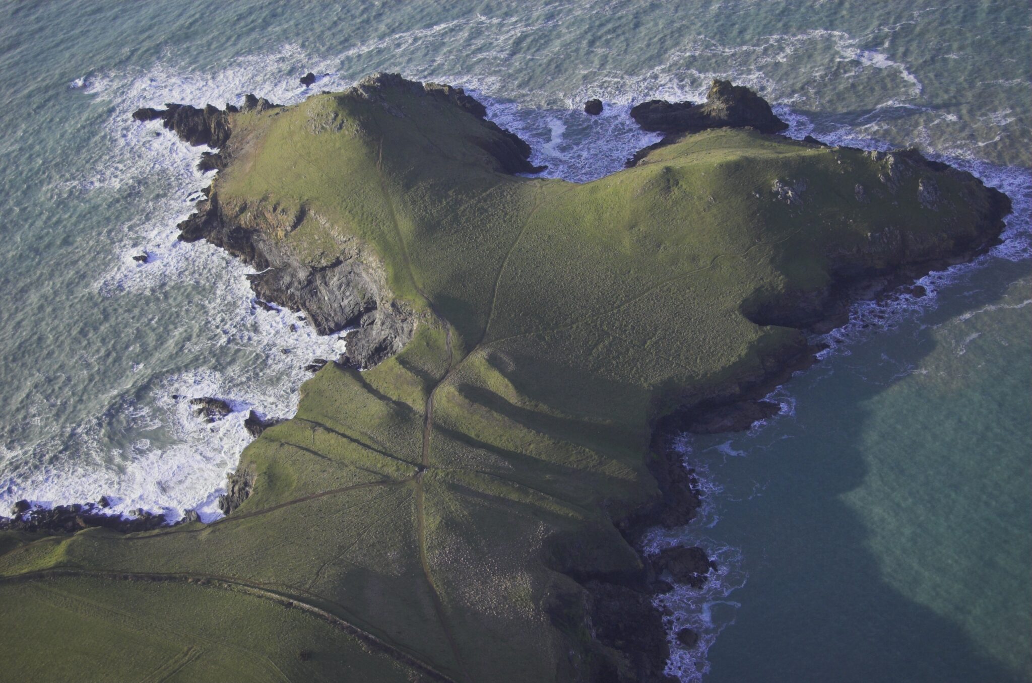
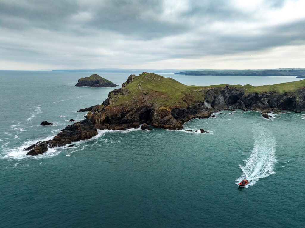
The Rumps is an ancient Cliff Castle projecting into the sea, built on an impressive promontory during the Iron Age over 2,000 years ago.

The Cornwall Farmland Bird Project set out to address the long-term decline of farmland birds by pairing detailed on‑farm bird surveys with practical, bespoke habitat advice. Many farmland species have…

Farming in Protected Landscapes (FiPL) is a programme providing grant-funding for Farmers and Landowners designed to deliver for People, Place, Nature and Climate. The programme is funded by Defra and delivered by Cornwall National Landscape.
FiPL is helping to address the climate and biodiversity crisis, improve people’s engagement with the landscape, and support sustainable farm businesses and communities.

Our aim is to strengthen the living connections between people, place, nature and climate so that Cornwall’s landscapes can thrive for generations to come.
To connect people, place, nature, and climate through digital innovation, amplifying voices and protecting Cornwall’s natural and cultural heritage.

Some Cornish Hedges are over 3,500 yrs old! Making them one of the oldest human-made structures still used for their original purpose. As old as the Pyramids, neither a hedgerow or a dry-stone wall, they are unique and mainly found in Cornwall.
Despite their importance, there is a significant gap in evidence at scale to fully capture the contributions of Cornish Hedges to ecosystem services and natural capital value.
The policies and objectives below are applicable to this Local Section – they should, however, be read in conjunction with the Cornwall AONB Strategy Aims, Policies and Objectives which are applicable to the whole designation.
Support small-scale existing slate quarries such as at Trebarwith, in order to allow controlled production for use in local works provided that these respect landscape character, topography and vegetation in their operation and restoration and minimise short and long-term landscape and visual impacts. Support further measures to protect and enhance environmental and landscape quality when existing quarrying permissions are reviewed, or any additional workings sought.
References to the main aims, policies & objectives
Seek better landscape integration of the A39, B3314, B3263, and other major roads with their rural AONB setting by improved planting design and management, reducing the impact of signage and lighting, use of non-intrusive methods of traffic calming and characteristic use and patterns of local materials and hedging styles in highways work.
References to the main aims, policies & objectives
Seek conservation and enhancement of the undeveloped character of the coast; for example, Witches Cauldron to Port Quin Bay, around High Cliff and around Dizzard in order to retain rugged and simple tranquillity and promote the enhancement of other parts of coast for example around Tintagel, Boscastle and Port Isaac such that they return to having a more undeveloped character.
References to the main aims, policies & objectives
 Policy LS-P1
Policy LS-P2
Policy LS-P3
Policy LS-P4
Policy LS-P6
Objective LS-Ob1
Objective LS-Ob2
Objective LS-Ob3
Objective LS-Ob4
Objective LS-Ob6
Policy LS-P1
Policy LS-P2
Policy LS-P3
Policy LS-P4
Policy LS-P6
Objective LS-Ob1
Objective LS-Ob2
Objective LS-Ob3
Objective LS-Ob4
Objective LS-Ob6
 Objective NRLM-Ob1
Objective NRLM-Ob3
Objective NRLM-Ob5
Objective NRLM-Ob9
Objective NRLM-Ob11
Objective NRLM-Ob1
Objective NRLM-Ob3
Objective NRLM-Ob5
Objective NRLM-Ob9
Objective NRLM-Ob11
 Policy CCBR-P1
Objective CCBR-Ob4
Policy CCBR-P1
Objective CCBR-Ob4
 Policy RSA-P1
Policy RSA-P3
Objective HWB-Ob2
Objective HWB-Ob5
Policy SCE-P2
Policy SCE-P3
Policy SCE-P5
Policy SCE-P6
Objective SCE-Ob1
Objective SCE-Ob4
Objective SCE-Ob5
Policy PD-P1
Policy PD-P3
Policy PD-P7
Policy PD-P12
Policy PD-P18
Policy RSA-P1
Policy RSA-P3
Objective HWB-Ob2
Objective HWB-Ob5
Policy SCE-P2
Policy SCE-P3
Policy SCE-P5
Policy SCE-P6
Objective SCE-Ob1
Objective SCE-Ob4
Objective SCE-Ob5
Policy PD-P1
Policy PD-P3
Policy PD-P7
Policy PD-P12
Policy PD-P18
Ensure that settlement growth to address local needs in Polzeath enhances the settlement edge, conserving and enhancing the natural beauty of the setting of the AONB. Ensure that the undeveloped coast between Polzeath, the southwestern end of the section, and the setting of ‘The Rumps’, is protected. Support new uses for isolated vernacular buildings where this can be achieved whilst maintaining their character and setting in order to facilitate their retention.
References to the main aims, policies & objectives
Seek a reduction of landscape and visual impacts of tourism including better integration of existing holiday sites, visitor infrastructure, car parks and signage. Pay particular attention to the increase in scale, massing, associated development and respecting local character in external works, landscaping, site design and layout at Polzeath, Tintagel, Bossiney and Trewethett.
References to the main aims, policies & objectives
Seek to improve the management of traffic, parking and vehicular access in this section, including through the promotion of car free options
References to the main aims, policies & objectives
Support initiatives for undergrounding visually intrusive wirescapes, for example at Port Isaac and Tintagel.
References to the main aims, policies & objectives
Support a landscape scale approach to extending and connecting currently fragmented locally characteristic habitats. These include maritime cliffs and slopes, lowland heathland, lowland meadows, coastal native woodland, and native valley broadleaved woodland found in various sections for example (but not limited to) in the Valency Valley, Millook Woods, Crackington Haven and St Nectan’s Glen.
References to the main aims, policies & objectives
Policy LS-P1
Objective LS-Ob1
Objective LS-Ob2
Objective LS-Ob3
Objective NRLM-Ob3
Objective NRLM-Ob5
Objective NRLM-Ob9
Objective NRLM-Ob10
Objective NRLM-Ob12
Objective NRLM-Ob13
Objective CCBR-Ob2
Objective CCBR-Ob3
Objective CCBR-Ob4
Policy RSA-P1
Objective RSA-Ob5
Objective HWB-Ob3
Objective SCE-Ob2
Support the encouragement of culm grassland in a manner that is consistent with conserving and enhancing local landscape character and biodiversity on coastal marginal land.
References to the main aims, policies & objectives
Support coastal management which promotes natural processes wherever possible, and support initiatives with communities which consider the long-term future of the coast in respect to predicted effects of sea level rise and increased storminess. Seek to support the delivery of appropriate measures to hold the line and manage realignment as identified in the Shoreline Management Plan where they conserve or enhance the landscape character and natural beauty of the AONB. Conserve the undeveloped nature of the coast away from settlements.
References to the main aims, policies & objectives
Policy LS-P1
Policy LS-P2
Policy LS-P3
Policy LS-P4
Objective LS-Ob1
Objective LS-Ob2
Objective LS-Ob3
Objective LS-Ob6
Objective NRLM-Ob9
Objective NRLM-Ob11
Policy CCBR-P1
Objective CCBR-Ob4
Objective CCBR-Ob5
Objective HC-Ob4
Policy RSA-P1
Objective RSA-Ob4
Objective HWB-Ob5
Policy SCE-P3
Policy SCE-P6
Objective SCE-Ob1
Objective SCE-Ob4
Support the improvement of the management of important seal sites between Beeny Sisters and Buckator, bringing them back into favourable condition for seals.
References to the main aims, policies & objectives
Consider small scale planting of local provenance native tree species such as Sessile Oak, Hazel and Alder to act as a future seed source for native woodland establishment where this is currently absent or sparse to assist subsequent natural regeneration.
References to the main aims, policies & objectives
Policy LS-P1
Objective LS-Ob1
Objective LS-Ob2
Objective LS-Ob3
Objective LS-Ob4
Objective LS-Ob5
Objective NRLM-Ob1
Objective NRLM-Ob2
Objective NRLM-Ob3
Objective NRLM-Ob5
Objective NRLM-Ob12
Objective NRLM-Ob13
Policy CCBR-P1
Objective CCBR-Ob1
Objective CCBR-Ob2
Objective CCBR-Ob3
Objective SCE-Ob2
Related topics and useful links
The Management Plan is a shared strategy for those who live, work and visit the Cornwall Area of Outstanding Natural Beauty.
Further details on the Monument Improvement Project


