Monitoring & Evidence
Our objectives can be achieved through various means such as but not...
View page
Oryon Torr Kelli ha Karn
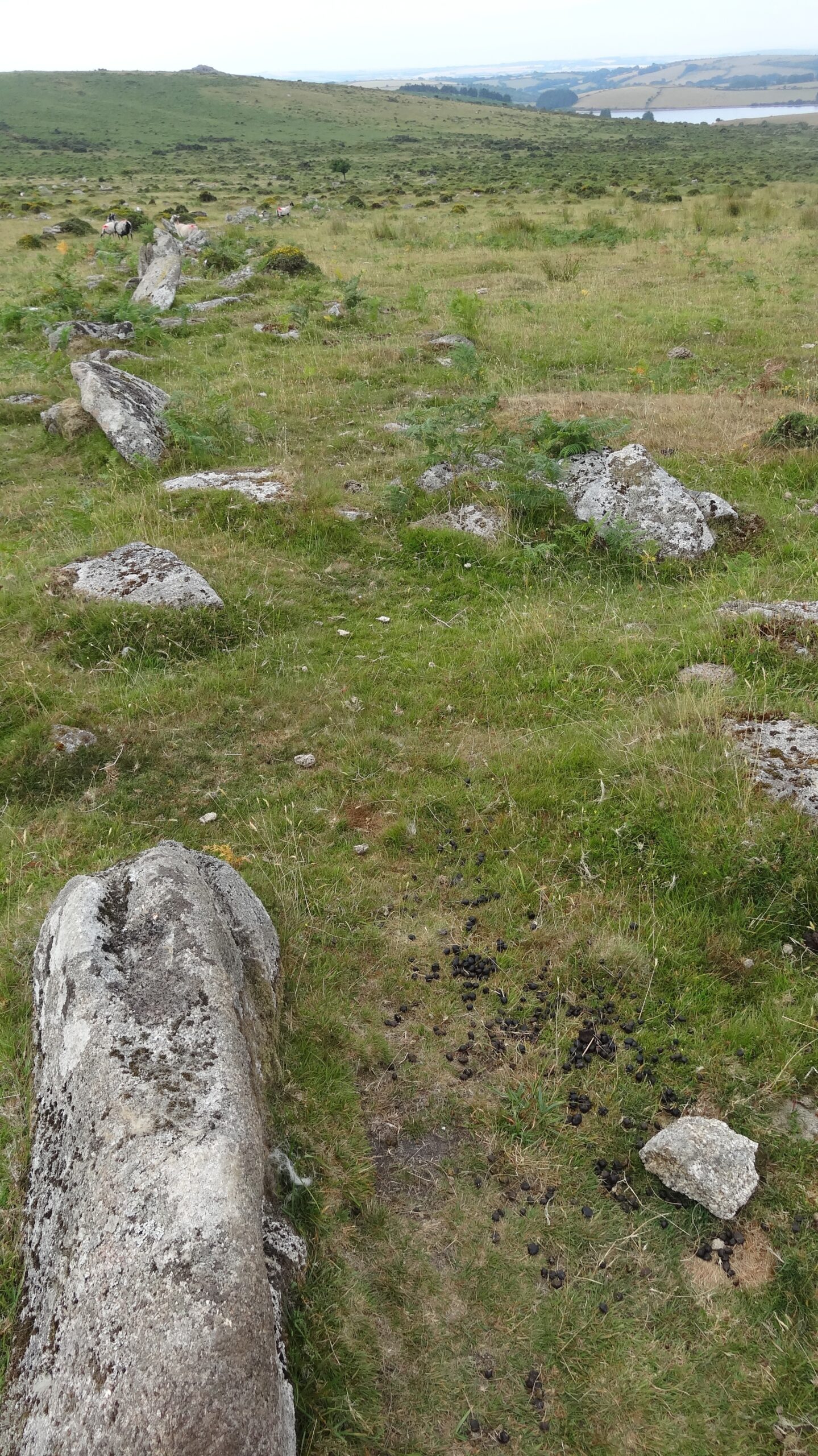
The Bearah Tor Boundaries are prehistoric stone banks and a cairn on Bodmin Moor that once marked out ancient land divisions and burial places, now hidden in parts by bracken and gorse
On the eastern spur of Bearah Tor, prehistoric field boundaries form three sides of a long rectangle, partly enclosing an area about 350 m by 130 m (around 11 acres). The land slopes down towards modern pasture, and walking its length would take about five minutes. Each boundary wall is made of low heaps of rubble and large boulders, over a metre wide and about half a metre high, now covered with turf and bracken. Sometimes large upright slabs (called orthostats) stick up about 0.5 m above the bank.
These walls mark a large section of hillside at high altitude. They may once have been used to keep animals in, though their exact purpose is unknown. Parts of the walls were damaged by stone-splitting in the 19th century. Their design is very similar to other boundaries on the eastern spur of Langstone Downs and is thought to date to the same period as nearby settlements and field systems.
Beside these boundaries, on Bearah Tor itself, is an oval prehistoric burial cairn (a mound of stones marking a grave). It is built against the steep side of the granite outcrop, rising nearly 3 m high, with rubble and boulders piled up to 1.75 m. The outcrop forms a striking feature on the skyline, making the cairn a prominent landmark.
Bearah Tor Boundaries was part of Cornwall National Landscape’s A Monumental Improvement Project, which aimed to ensure that 40 scheduled monuments across Cornwall National Landscape were better protected, identified and enjoyed by a wider range of people. Between 2022 – 2025, the Project delivered conservation repairs, installed new heritage interpretation signage, ran a range of community volunteering events and developed new website resources. The Project was primarily funded thanks to The National Lottery Heritage Fund, with support from our other partners – Cornwall Council, Historic England, The National Trust, Cornwall Heritage Trust and Cornwall Archaeological Society.
The linear boundaries on Bearah Tor have survived fairly well, even with some stone-splitting in recent times. Their closeness to settlement sites, field systems, and cairns from the same period shows how land was organised and used by prehistoric communities, and gives clues about their farming practices.
The remains of stone working and quarrying on the surrounding moor also tell part of the story of our industrial past. They help us understand how the use of this upland landscape has changed over time.


The most striking feature here is the network of prehistoric field boundaries. These stone banks, some over 300 metres long, still run across the hillside, with upright stones poking through the turf in places. Standing on the tor, you can see how they frame the land below, giving a sense of the scale of prehistoric farming. The round cairn, built against a granite outcrop, is another highlight. Its heap of stones, still rising to nearly two metres, was carefully shaped around the natural rock, with a tall granite slab set upright at its edge. Together, the boundaries and cairn link the practical and the spiritual one dividing land, the other marking a burial place.
Bearah Tor itself is a dramatic backdrop. The granite outcrops crown the ridge, and from here you get sweeping views across Bodmin Moor. Looking out, it’s easy to imagine why prehistoric communities chose this spot, the boundaries and cairn would have stood out clearly on the skyline, visible from far across the moor. Even today, the combination of natural rock, stone-built remains and wild open scenery makes this site a powerful and memorable place.
The landscape around Bearah Tor is shaped by rough grazing and open common land. In well-grazed areas, short grasses cover the ground, dotted with hardy plants like heather and mosses. Elsewhere, bracken dominates, growing tall in summer and creating thick cover that hides the stone boundaries. Gorse also grows in patches, adding bright yellow flowers in spring but spreading quickly if left unchecked. Sheep do graze freely across the moor, helping to keep some of the vegetation down.
Visitors can help by sticking to clear paths where possible and avoiding climbing on the stone banks or cairn. This helps prevent further wear on the fragile remains. Taking part in volunteer clearance days, when available, is another way to contribute, these activities carefully cut back vegetation under archaeological guidance so the ancient boundaries remain visible.
The biggest challenge facing Bearah Tor Boundaries is vegetation. Bracken and gorse spread quickly and can cover or even damage the stone banks and cairn. Without regular management, the archaeology becomes hidden and harder to protect. Clearing bracken by hand, cutting back gorse and encouraging grazing are all vital tasks, but they require time, resources and supervision to make sure the remains are not harmed. Quarrying in the past has already disturbed parts of the site, so careful conservation today is even more important to keep what survives.
Bearah Tor Boundaries becomes Oryon Torr Kelli ha Karn in Cornish.
It means oryon – boundaries, torr – tor, kelli – grove, ha – and karn – cairn.
Plan your visit with essential details on transport and parking options, available facilities, route descriptions and accessibility information to ensure a comfortable and enjoyable experience at any of our historical monuments.
When enjoying the countryside, it’s important to follow the Countryside Code to protect nature and preserve its beauty for everyone. This includes simple, respectful actions like not littering, always take your rubbish home or dispose of it properly in bins. Stick to designated paths to avoid damaging crops or wildlife habitats, and keep gates and property as you find them, whether open or closed. Be mindful of livestock and wildlife by keeping dogs under control and not disturbing animals. By following these guidelines, you contribute to the protection of the environment and ensure that others can enjoy the countryside as well.
This is an open moorland site with no formal paths. The ground is uneven, often steep and covered in bracken, making access challenging for many visitors.
There are no visitor facilities on site. The tor is a wild, open landscape, so come prepared with sturdy footwear and supplies.
There is no dedicated parking at the site itself. Access is best planned as part of a wider walk across Bodmin Moor.


You can play a part in preserving Cornwall National Landscape’s beauty and history for future generations. Volunteering opportunities range from helping with conservation efforts to assisting with educational programmes and community events. Whether you have a passion for nature, history, or simply love the outdoors, there’s a way for you to contribute. Join us and make a difference while connecting with others who share your enthusiasm for Cornwall’s heritage. Scroll down and follow the links to our Volunteering Hub to find out more!

Cornwall National Landscape is a non-profit organisation that conserves the unique landscapes, wildlife, and cultural heritage of Cornwall. Volunteering for the protected landscape provides a rewarding experience of giving back to the community and preserving the Cornwall's natural beauty.

Discover a wealth of knowledge in our Resources section, where you can download detailed research documents, reports, and source material compiled by our archaeology team to enhance your understanding of the site.